
Page 26 - Norwegian Spacial Mission
P. 26
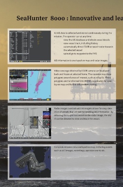
SeaHunter  8000 : Innovative and leading edge mission data presentation


                                          All AIS data is collected and stored continuously during the
                                          mission. The operator can at any time:
                                          -      view the AIS database and obtain vessel details
                                          -      view vessel track, including history
                                          -      automatically direct EO/IR or search radar towards
                                                 the selected vessel
                                          -      upload go-to waypoint to the FMS

                                          AIS information is overlayed on map and radar images.


                                          Video coverage obtained by EO/IR camera can be played
                                          back and frozen at selected frame. The operator may draw
                                          polygons around areas of interest, such as oil spills. These
                                          polygons are transformed into WGS84 coordinates for over-
                                          lay on map and further information sharing.


                                          Radar images overlaid with AIS targets allows for easy dete-
                                          ction of vessels that are not transmitting AIS information. By
                                          selecting the suspicious vessel on the radar image, the EO/
                                          IR can be directed to view and track the vessel.


                                          Complete mission data overlayed on map, including events
                                          such as still images, recordings, operator events etc.